Applied Astronautics
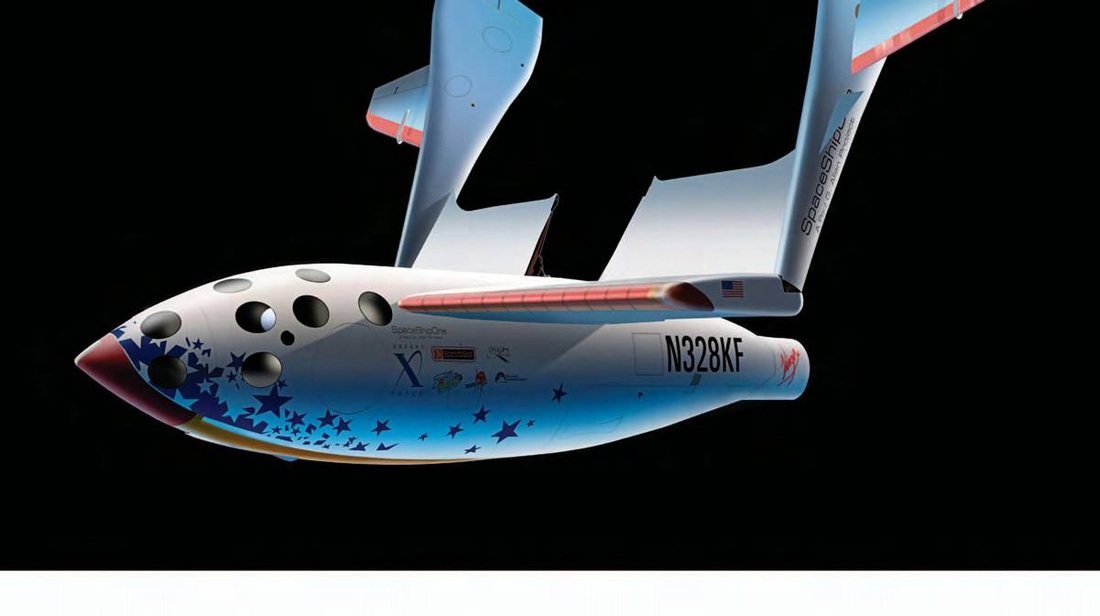
Space tourism is ready to take off, and in the next decades it will become an adventure within the reach of many pocketbooks. In 2004 Space ShipOne became the first private manned vehicle to reach near outer space and to remain outside the atmosphere for three minutes. Then it made a problem-free landing in the California desert. The project cost $20 million and was financed by one of the founders of Microsoft. Some people are already making reservations to fly in the craft and experience microgravity. It bears mentioning that manned space programs led to the development of various technologies, including cordless devices, implanted cardiac defibrillators, and digital imaging, to mention just a few.
From Space to Home
Space has been a laboratory for investigating and developing new technologies and methods, the applications of which have found a place in daily life. Various devices, foods, clothes, materials, and utensils have been tested in space under extreme conditions and have become useful in improving our lives. Scientists say that the technological innovations of the next 50 years will change society in such a way that a change in overall thinking will be necessary to assimilate them.
Intelligent Clothing
Clothing with computers and other technological capabilities incorporated into them has passed from the fiction of futurist movies to a reality that is getting closer and closer. New clothing has been designed to demonstrate how electronics can transform something to wear into intelligent,biometric clothing that responds to surrounding environmental conditions and to the wearer's vitals signs. Thanks to the new types of cloth, scientists are already talking about garments to prevent diseases.
Domestic Uses
Frequent space travel has brought the application of new technologies to the home environment. Such is the case with microwave ovens and dehydrated food. It is only recently that they became part of the daily routine of the family in the home
Air Purifiers
Air purifiers are designed to reduce the concentration of bacteria in the home and are beneficial for people suffering from allergies or asthma. Air purifiers are portable and can be carried from one room to another.
Global Interconnection
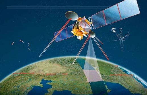
Communications using satellites have made it possible to connect places that are very far from one another and to bring information to very remote regions. The satellites are primarily in geosynchronous orbits—that is, the satellite orbits in the same time it takes the Earth to rotate. This motion allows for more effective transmission systems, because the satellite is stationary with respect to the Earth's surface. There is a virtual fleet of geosynchronous satellites dedicated to various goals: meteorology, research, navigation, military uses, and, obviously, telecommunications.
Connections
Communication can be established between any two points on Earth. The signals sent and received between terrestrial and satellite antennas are in the radio-wave spectrum, and they range from telephone conversations and television to computer data. A call from Europe to the United States, for example, involves sending a signal to a terrestrial station, which re transmits the signal to a satellite. The satellite then re transmits the signal so that it can be received by an antenna in the United States for transmission to its final destination.
Terrestrial Stations
These stations are buildings that house the antennas and all the necessary equipment on land for sending and receiving satellite signals. The buildings can be large structures, and the antennas can act as receivers and transmitters of thousands of streams of information. In other cases, they are small buildings equipped for communications but designed to operate on board ships or airplanes.
Global Satellite Navigation
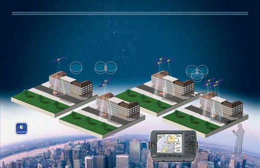
The Global Positioning System (GPS), developed by the U.S. Department of Defense, makes it possible to determine the position of a person, a vehicle, or a ship anywhere in the world. The GPS system, which uses a constellation of two dozen Navstar satellites, became fully operational in 1995. Although it began as a military initiative, the GPS system was soon extended to commercial applications, which now include handheld navigation systems. A new development is the proposed European Galileo satellite navigation system, which resembles the GPS system but would use a constellation of 30 satellites. The European system is projected to become operational by 2013.
Operation
Based on the electromagnetic waves sent by the satellite, the receivers can convert signals received into position, velocity,
and estimated time, because the distance is the product of the velocity and the time. Four satellites are required to calculate the exact position. The first three form an area of triple intersection, while the fourth functions as a checking mechanism. If the area swept out by the fourth satellite does not coincide with the intersection determined by the other three, the position must be corrected.
PHASE 1
The first satellite sends its coordinates. The navigation receiver captures a signal, which indicates at what distance the satellite is located anddefines a sphere of possible locations.
PHASE 2
Using the coordinates of a second satellite, the receiver can determine the user's location as being anywhere along the intersection of the two spheres.
PHASE 3
Combining three satellites allows a common point to be determined to indicate the exact position of the navigator.
PHASE 4
With a fourth satellite, errors in the determined position introduced by inaccuracies in the receiver's clock can be corrected.
Galileo System
The European Galileo project (which placed its first experimental satellite into orbit in late 2005) is a satellite navigation system that will be based on a constellation of 30 satellites (27 operational and 3 spares) in three medium Earth orbits in different planes to ensure global coverage. As with the GPS navigation system, it will permit a variety of applications in addition to navigation, such as the management of taxi fleets in large cities and the ability to locate stolen automobiles or other property. The Galileo project arose in part to gain independence from the GPS system, which could be interrupted or modified to be less accurate if deemed necessary by the U.S. government.
Environmental Satellites
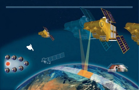
Spot 1 was put into orbit in 1986 with the sponsorship of the French Space Agency (CNES). It was the first satellite of what is today a constellation of satellites that can take photographs of different
places on the Earth at very high resolution. Spot 5 can scan the Earth from three different angles, which makes it possible to construct three-dimensional images. Today Spot 5 is a commercial satellite par
excellence, contracted by a variety of firms for close-up images. For example, agricultural firms request very close-up images of land under cultivation, and petroleum companies can request images for oil
and gas exploration. Landsat, another satellite for monitoring the environment, was launched in 1999 and offers images of lower resolution.
Spot 5 Capabilities
The development of the Spot satellite constellation has made it possible to commercialize photographic monitoring of environmentally linked phenomena. Using its scanning system, a Spot satellite can observe the same site every two or three days. Each satellite carries two cameras, which can provide side-by-side coverage for a track 73 miles (60 km) wide at ground level. Used in combination, the cameras can obtain a resolution as fine as 8 feet (2.5 m), or they can be aimed at different angles to produce stereoscopic images. The cameras can be used to produce black-and-white images or multi spectral images that combine more than one wavelength of light. Depending on the area, Spot Image, the company that markets Spot images, can guarantee pictures without cloud cover. This is particularly valuable for applications that require images without clouds, fog, mist, or sandstorms.
How These Photographs Are Taken
From Toulouse, France, depending on the meteorological forecast, the Spot Image programming teams make plans for the satellites to take images over the next 24 hours to obtain the photographs that are on order. Acquiring two photos simultaneously makes for better pictures and facilitates an automatic configuration process for comparing two images.
From the Air
Photographs taken by Spot 5 can show the geography of any region of the world indifferent scales, from images of 8 feet(2.5 m) on Earth to fringe areas 37 miles (60km) wide. Spot 5's high-definition capacity makes in-depth close-ups possible; it can target very specific places, from areas of vegetation to harbors, oceans, geographic borders, and forest-fire zones. Here Israel and its border regions—with Syria, Lebanon,and Egypt—together with the Dead Sea and the Golan Heights were photographed by the satellite, offering a panoramic image with significant detail.
A Different Vacation
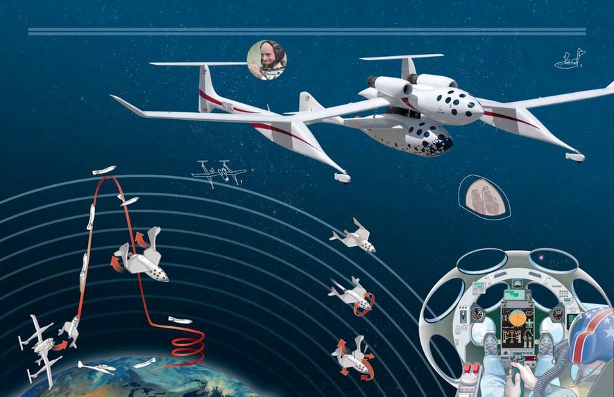
Perhaps a few years from now traveling to the edge of space will be another option for a vacation. Right now various private enterprises already have plans to offer this type of recreation. In April 2001 an American businessman, Dennis Tito, made a successful trip to the International Space Station. The first commercial space traveler, he paid $20 million for an eight-day stay. One year later, the Australian Mark Shuttle worth did the same. Then came the formation of Space ShipOne, which has the potential of allowing thousands of tourists to travel to space at moderate cost.
